Traffic & Parking
scroll to: getting there / parking / road closures & traffic management
GETTING THERE
The tranquil rural village of Coatesville is located on the northern fringes of Auckland, just outside the built-up suburban area . From Auckland City and the North Shore, you'll access the event via the Northern motorway to Albany. From the west, the Coatesville-Riverhead highway will carry you to the venue from just south of Kumeu.
As there is very limited public transport in the area at the best of times - and none to speak of first thing on a Sunday morning - almost all participants will arrive by car. With many of the roads in the area fully closed to traffic throughout the event, street parking is in very short supply. For this reason, we ask all participants to make use of the dedicated event parking in the adjacent Coatesville Pony Club. Not only is this parking area carefully managed to produce the minimum impact on the event, it is also super convenient.
Tip: If you are unfamiliar with the venue, set your GPS to...
4 Mahonui Valley Road, Coatesville, Auckland
... which takes you right to the start line.
On race morning, you'll be directed from here to the car park entrance on Glenmore Rd.
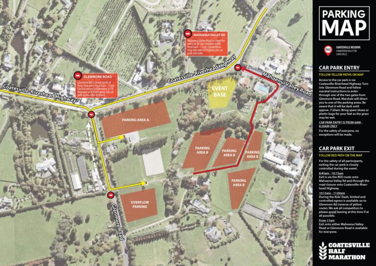
Parking Map
With little in the way of other transport options, most participants will opt to drive to the event. We encourge all participants to check in with friends, family and running mates and to car pool wherever possible. As a rural area, street parking in Coatesville is extremely limited and the major roads nearby are all closed for the event. Therefore we encourage all participants to park in the dedicated event parking area in Coatesville Pony Club. This is close to the venue, well controlled and efficiently marshalled.
Access to the car parking area is only available by turning into Glenmore Road from Coatesville-Riverhead Highway. You must be in the parking area by 8:30am and egress is also closely controlled during the event as you will have to cross the path of runners to exit the area. Check the parking map closely and follow the instructions of our parking marshals on race day.
ROAD CLOSURES
& TRAFFIC MANAGEMENT
It is imperative for the safe operation of the event that certain roads are closed to traffic at specified times on race day. The map below lists the road closures and other traffic management measurements that will be in place on race day so you know what to expect, when to expect it and for how long.
Info for Residents
Traffic restrictions are imposed for the minimum time possible to create as little delay and inconvenience as we can to local residents. Unless it would be unsafe to do so, residents will be permitted access to and from the homes during the event. Please be respectful of the entrants and aware that they are permitted to be on the road at this time. Please drive no faster than walking pace whilst operating a vehicle within the closure area. Keep a close lookout for pedestrians who may approach faster than you expect or from unexpected directions.
The event organisers wish to place on record their sincere thanks to Auckland Council, Auckland Transport and local residents for their assistance in the safe operation of this fun community focussed, fitness event.
Road Closure & Traffic Management Map
Spend time in the countryside this summer ...
... sign up for the Coatesville Half Marathon here.

